Thuis
Volledig
Aanmelden
Afdrukken
Route to the Campsite

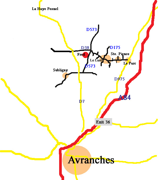
Route to the camping (See Address for GPS coordinates):
- On the motorway A84 take Exit 36 for Le Parc
- On the roundabout take the first exit in the direction of Le Parc (D975)
- After ± 6 km you arrive in Le Parc, take a left turn at the traffic lights in the direction of Ste. Pience (D39)
- After ± 4 km in Westwards direction (passing through the villages Ste. Pience and Le Luot) turn left in the direction of Chavoy (D573)
This is the third exit to the left on the D39, ±1.5 km after Le Luot (after the sign for the end of the village Le Luot) (D573)
- After ± 250 meter you will find the camping on the right (the entrance can be recognized by the camping sign)
If you use a navigationsystem then be aware that the shortest route can possibly lead you via vary small roads.
When the navigation system does not recognize the address and you cannot use GPS coordinates then use the junction between 2 roads (D39 and D573).
That brings you at 250m of the camping and a sign will show you the direction to the camping.
Watch out:
When using only the city in your navigationsystem this will lead you to Subligny but the camping is a couple of kilometers outside Subligny.
Google Route Description
Use this link for a route description using Google Maps
(but avoid the small roads especially with a caravan)
or use the route descriptions on this page.